ATTENTION: The works hosted here are being migrated to a new repository that will consolidate resources, improve discoverability, and better show UTA's research impact on the global community. We will update authors as the migration progresses. Please see MavMatrix for more information.
Show simple item record
| dc.contributor.author | Kennedy, Walter Lyman | en_US |
| dc.date.accessioned | 2009-09-16T18:20:36Z | |
| dc.date.available | 2009-09-16T18:20:36Z | |
| dc.date.issued | 2009-09-16T18:20:36Z | |
| dc.date.submitted | January 2008 | en_US |
| dc.identifier.other | DISS-10151 | en_US |
| dc.identifier.uri | http://hdl.handle.net/10106/1882 | |
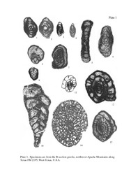
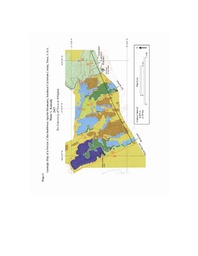
| dc.description.abstract | Middle Permian marine (Bell Canyon Formation) strata along the southwestern margin of the Delaware Basin in southeastern Culberson County, Texas provide excellent exposures of basinal and slope strata, useful fossils for age dating, and a variety of interpretations of possible depositional environments. This work includes a detailed surficial geologic map of about a seven square kilometer area of the northwestern Apache Mountains, located along a portion of Texas Farm Road 2185, about 60 kilometers northeast of Van Horn, Texas. In addition to the map, a stratigraphic column is presented along with descriptions of a major subaqueous gravity flow in the map area and significant structural relationships recognized in the map area. Descriptions of the Upper Guadalupian Bell Canyon Formation and the overlying Lopingian Castile and Rustler Formations are presented to aid in providing a framework for proposed biostratigraphic correlation with similar age strata in the Guadalupe Mountains, 70 km to the north-northeast of the map area. Analysis of one of the major, thick subaqueous gravity flows within the Bell Canyon Formation provides information about its clast lithology, fossil content, lateral extent, timing of emplacement and allochthonous debris origin. | en_US |
| dc.description.sponsorship | Nestell, Merlynd | en_US |
| dc.language.iso | EN | en_US |
| dc.publisher | Environmental & Earth Science | en_US |
| dc.title | Geology Of The Northwestern Apache Mountains, Southeast Culberson County, West Texas, U.S.A. | en_US |
| dc.type | M.S. | en_US |
| dc.contributor.committeeChair | Nestell, Merlynd K. | en_US |
| dc.degree.department | Environmental & Earth Science | en_US |
| dc.degree.discipline | Environmental & Earth Science | en_US |
| dc.degree.grantor | University of Texas at Arlington | en_US |
| dc.degree.level | masters | en_US |
| dc.degree.name | M.S. | en_US |
| dc.identifier.externalLink | http://www.uta.edu/ra/real/editprofile.php?onlyview=1&pid=90 | |
| dc.identifier.externalLinkDescription | Link to Research Profiles | |
Files in this item
- Name:
- Kennedy_uta_2502M_10151.pdf
- Size:
- 5.170Mb
- Format:
- PDF
- Name:
- PLATE1.pdf
- Size:
- 553.2Kb
- Format:
- PDF
- Name:
- Map(I).pdf
- Size:
- 442.6Kb
- Format:
- PDF
This item appears in the following Collection(s)
Show simple item record